Highlights
Highlights
Benefits
- Acquire simultaneous microresistivity, acoustic, and ultrasonic images in oil-based mud systems
- Benefit from additional solutions including image processing and multi-wall sedimentological studies
- Save rig time through additional interpretation of complimentary data
Applications
- Dip and strike determination
- Fault and fracture identification and description
- Sedimentary and stratigraphic interpretation
Overview
The Baker Hughes EARTH Imager™ service gives you high-resolution microresistivity images from wells drilled with nonconductive, oil-based muds. Advanced electrical conductivity measurements deliver petrophysical and geological evaluation at a much higher resolution than ever before in oil-based mud systems.
Capture detailed formation features with combined measurement capabilities
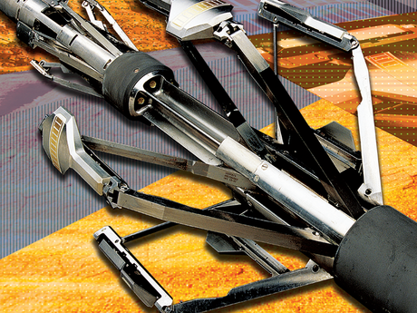
The EARTH Imager service is a wireline logging tool designed to deliver higher vertical resolution and wider borehole coverage compared to previous systems. The service achieves this through its independently articulated, six-arm carrier and power standoff design, which ensures optimal sensor-to-formation contact, even in highly deviated wells.
Each of the six arms includes a pad with eight sensors. As a result, the service can acquire 48 microresistivity measurements that capture detailed features for identifying bedding, fractures, faults, stratigraphic features, and borehole wall features such as breakout and drilling-induced fractures.
The EARTH Imager service is fully compatible with other logging tools in our portfolio. The service allows simultaneous acquisition of high-resolution resistivity and acoustic borehole image data sets. When deployed in combination with acoustic imaging services, such as the Circumferential Borehole Imaging Log™ (CBIL™) service or the UltrasonicXplorer™ service, the EARTH Imager service helps analyze:
- Structural dip
- Fractured systems
- Depositional environments
- Borehole stability
- Net-pay in thinly bedded sequences
Because this unique capability is based on two sets of complimentary data, you get a powerful interpretation perspective that also saves rig time.
Contact us today to learn how the EARTH Imager service can improve your formation analysis in oil-based mud systems.


